Skip to content

Life On Lantau, the trusted provider of island-wide news and information

 COMMUNITY

SOUTH LANTAU

About The Area

South Lantau is the southern part of Lantau Island, the biggest island in Hong Kong. The whole area is very green and not so densely populated. The largest town in South Lantau is Mui Wo. Just a 30-minute ferry ride from Central, Mui Wo has a number of shops and restaurants, and a long, sandy beach with barbecue pits (please note that that the beach facilities are currently being upgraded, therefore the barbecue pits are closed at the moment and there are no lifeguards on duty on the beach).

Further along the coast are a number of smaller towns, including Pui O, Cheung Sha and Tong Fuk, where you’ll find a range of laid-back beach restaurants. Also accessible via South Lantau is Tai O, a picturesque fishing village with traditional stilt houses over the water.

A popular area for families, South Lantau is also home to herds of cows and buffaloes, who roam freely around the wetlands, streets and beaches.

HIKES IN THE AREA

The largest island in Hong Kong, Lantau is a hiker’s dream, with numerous trails to tread and peaks to climb. Split into sections, the 70km-long, circular Lantau Trail consists of a number of different walks of varying difficulty. Starting in Mui Wo, the first sections of the trail are tough, passing over Sunset and Lantau Peaks, bringing you out at Lantau’s famous Big Buddha. From there, the trail becomes a little easier as it continues on to the traditional fishing village of Tai O before looping back along the south of the island to its beginning.

* Bay Media Limited assumes no responsibility for any damage, injury, death or loss of any kind as a result of the use of information regarding hiking trails on this website. Readers using this information accept that they are doing so at their own risk. All information regarding hikes and activities is provided as general information only, and it is the responsibility of each person to conduct their own verification of that information and all necessary preparation for any specific hike or activity.

The Lantau Trail

DISTANCE: 2.5km. DURATION: APPROXIMATELY 0.75 HOURS. DIFFICULTY RATING: 2/4

Getting there: Take the ferry from Pier 6 in Central to Mui Wo.

Starting at Mui Wo ferry pier, head to your right and then turn left at the roundabout onto South Lantau Road. Follow the road as it winds uphill to Nam Shan, where you will find a resting area with benches, barbecue pits and public toilets.

DISTANCE: 6.5km. DURATION: APPROXIMATELY 2.75 HOURS. DIFFICULTY RATING: 4/4

Getting there: Take any bus from Mui Wo bus station. Get off at the Nam Shan picnic area as the bus climbs up the hill.

Starting at distance post L005 at Nam Shan, climb the stone steps and follow the path, going straight on, past the helipad. The trail is shaded in places at first, but soon opens up to views back over Mui Wo. At post L011, keep left, and continue the climb up Sunset Peak, the second highest peak on Lantau at 869m. Keep to the left as you go, heading towards Tung Chung Road, which runs between Sunset and Lantau Peaks. At post L013, a number of huts will come into view.

The path does not directly go over the peak’s summit, however it is possible to take a detour to the right to reach the top if you wish to do so.

The views from the trail as it heads downhill are incredible, with stunning vistas of the South Lantau coast and the uninhabited Soko Islands. This second section of the Lantau Trail ends at post L018 at Pak Kung Au, where you will find picninc spots on both sides of Tung Chung Road.

From here, you can catch the bus to either Tung Chung or Mui Wo.

DISTANCE: 4.5km. DURATION: APPROXIMATELY 2.25 HOURS. DIFFICULTY RATING: 4/4

Getting there: Take the bus from Mui Wo or Tung Chung and alight at Pak Kung, the highest point on Tung Chung Road.

Without doubt the hardest section of the Lantau Trail, stage 3 starts at distance post L018 on Tung Chung Road, and involves a steep climb to the top of Lantau Peak, including many steps. The highest point on Lantau, and the second highest in Hong Kong, Lantau Peak rises 934m above sea level and offers incredible panoramic views of the island. A shelter sits at the top to provide refuge in case of bad weather.

Almost as tough as the climb to the top is the descent towards Ngong Ping, with large, steep steps that can be rather hard on the knees. Keep going until you reach a resting area, with picnic benches and maps of the area. Here, the path splits, the left-hand track heading downhill towards Shek Pik reservoir. This is a very pleasant walk, but is not part of the Lantau trail. The Wisdom Path, with 38 columns featuring Buddhist prayers, is located here.

DISTANCE: 4km. DURATION: APPROXIMATELY 1.25 HOURS. DIFFICULTY RATING: 2/4

Getting there: Take bus number 23 from Tung Chung, bus number 2 from Mui Wo, or the Ngong Ping cable car from Tung Chung.

If you are starting from Ngong Ping, follow the signs for the youth hostel. Keep going until you reach the Wisdom Path. Here, 38 wooden columns tower over the hillside, each inscribed with Buddhist prayers. The junction here also affords beautiful views over Shek Pik reservoir with its 700-metre long dam.

From the Wisdom Path, follow the signs for the Lantau Trail, away from Lantau Peak. The path is fairly easy at this stage. When you reach the entrance to Ngong Ping campsite, take a left, heading up the rocky stepped path. The Wisdom Path and Big Buddha will come into view across the valley to your left.

The path heads downhill through the trees towards the Ngong Ping View Compass Point, which offers great views from north to south. From here, you can see both the entrance and exit to the tunnel section of the Hong Kong-Zhuhai-Macau bridge.

When you reach the bottom of the stony path, take a left onto the concreted path. Follow the path until you reach the Ngong Ping retail village. Head through the village to the bus station.

If you are ending your hike here, you can take the number 11 bus to Tung Chung or the number 1 or 2 bus to Mui Wo. If you are carrying on, head downhill on the main road and follow the hairpin round to the left at the junction with Keung Shan Road. Keep going downhill until you see the large gateway to the next section of the Lantau Trail ahead of you.

DISTANCE: 7km. DURATION: APPROXIMATELY 2.75 HOURS. DIFFICULTY RATING: 3/4

Getting there: From Mui Wo or Tung Chung, catch the bus towards Ngong Ping or Tai O. Alight at the first stop after the Tai O Road junction and walk back to the start of the trail.

Starting at the intersection of Sham Wat Road and Keung Shan Road, section 5 of the Lantau Trail begins at distance post L035, where you will find a picnic site set back form the road. From here, follow the yellow sign for Man Cheung Po and head uphill. The climb is shaded to begin with, through the ‘Feng Shui Woods.’ At post 37 you will have great views to both sides of the island.

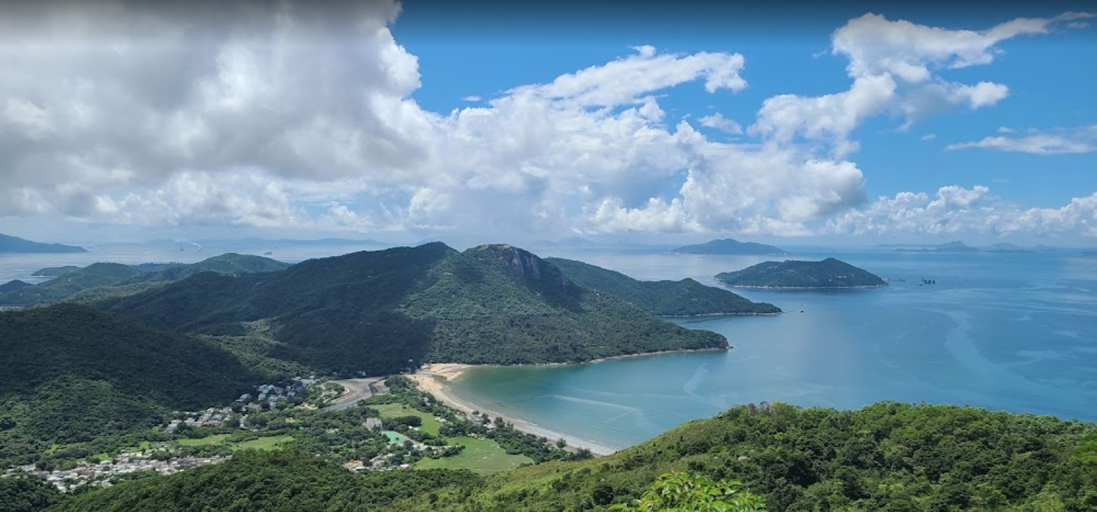
Continue with the reservoir on your left, heading downhill then up again. The trail is easy to follow, although challenging at times, with steps along the way. Eventually you will reach Keung Shan, which peaks at 459 metres. At the fork in the path, keep left towards Ling Wai Shan, which stands at 490 metres. At the top, you can enjoy panoramic views and see the sea all around you.

From there, head downhill. The path is fairly steep. Where the path splits, turn right towards Man Cheung Po. At the next fork in the road, keep going straight on heading towards Tai O. The path here rises and falls and is very rocky.

The path heads round to the right where it meets a large stream. At the next split, head downhill, following the signs for the Lantau Trail. This section of the walk is very peaceful, with lots of trees and streams. Pass the entrance to Man Cheung Po campsite and continue on the concreted path. Keep following the yellow signs as you go.

Eventually you will reach Lung Tsai Ng Yuen, a striking, deserted villa. Next to the property is a beautiful pond with a pagoda. Continue to the end of section 5, at distance post 50.


DISTANCE: 2.5km. DURATION: APPROXIMATELY 1 HOUR. DIFFICULTY RATING: 2/4

Getting there: Continue on from stage 5 or take a bus from Mui Wo or Tung Chung towards Tai O, alighting as the bus heads down into the Keung Shan Valley. From there, follow the country park road to distance post L050.

At post 51, take the unpaved path. The route is somewhat shaded, and you will cross a beautiful stream with stepping stones.

The path down towards Tai O is extremely steep and long. At the bottom, turn left. If you are ending your hike here, turn right towards Tai O, past the playground on your left. From Tai O, you can catch the bus to Mui Wo or Tung Chung, or take the ferry to Tung Chung.

If you are continuing, go straight ahead rather than turning right.

DISTANCE: 10.5km. DURATION: APPROXIMATELY 3 HOURS. DIFFICULTY RATING: 3/4

Getting there: Catch a bus from Mui Wo or Tung Chung, or take the ferry from Tung Chung pier.

* The following notes are based on the ‘old’ version of the trail. Note that farmland rehabilitation is currently in progress and access to part of the trail is not permitted by the landowners at present. The government therefore recommends taking alternative routes from distance post L059. See hiking.gov.hk/eng/longtrail/ltrail/ltrail/ltrail07.htm for more details.

Starting at Tai O, head south to join the trail. With the sea to your right, pass by the village houses. Keep going along the coast. The trail is fairly easy at this point and is all concreted. There is some shade along the way before the view opens up across a beautiful bay area. A short distance later, you will pass some small temples on your left.

The path turns off to the left and passes through a farming area with rice paddies and other vegetation. Follow the path round to the left then to the right. After a short distance, you will see a yellow sign confirming you are on the right path. The path once again joins the coast, passing by some beautiful, white, sandy beaches. The path is steep in places, with large, stone steps heading downhill.

Eventually, you will come to a T juction. The Lantau Trail heads to the left. For those wishing to visit Fan Lau Fort, you can take a detour to the right here. You will then come to another T junction where you can turn right onto the beach and then head uphill on the Fan Lau Country Trail to Fan Lau Fort. You can then rejoin the Lantau Trail from Fan Lau beach.

If you turn left to stay on the Lantau Trail, you will head through Fan Lau village, after which the path climbs, offering stunning views of the beaches below.

Stage 7 ends above Kau Ling Chung beach at the catchwater, where you can choose to either head back to Tai O via Man Cheung Po or turn right to continue on to stage 8.

DISTANCE: 5.5km. DURATION: APPROXIMATELY 1.5 HOURS. DIFFICULTY RATING: 1/4

Getting there: Stage 8 of the trail is usually accessed via stage 7.

Continuing on from stage 7, stage 8 of the Lantau Trail starts at the entrance to the Kau Ling Cheung Campsite. Follow the trail along the catchwater towards Shek Pik. The path is well shaded and has a number of picnic areas, as well as more great views. This section of the trail ends at Wang Pui Road, where you will find some very clean public toilets.


DISTANCE: 6.5km. DURATION: APPROXIMATELY 2 HOURS. DIFFICULTY RATING: 2/4

Getting there: Take any bus from Mui Wo or Tung Chung towards Tai O or Ngong Ping. Alight after the bus crosses the Shek Pik dam.

Starting at Wang Pui Road, walk across the Shek Pik dam, which separates Shek Pik reservoir from the prison. To your left, high up in the hills, is the Big Buddha.

After crossing the dam, turn right, keep left at the fork in the road, then follow the road round to the right. The path then heads to the left, through the trees. Eventually it starts to climb, with large stone steps taking you up the hill. After you reach the top of the hill, the path descends and becomes shaded. It then opens up and tracks near the coast.

After heading downhill, the path passes by a beautiful beach. After that point, it climbs steeply with large stone steps. Eventually, the trail meets a service road. Turn left here and make your way into Shui Hau village until you come to distance post L100. From here, you can catch the bus to Mui Wo or Tung Chung.

DISTANCE: 6.5km. DURATION: APPROXIMATELY 2 HOURS.

Getting there: Take any bus from Mui Wo or Tung Chung towards Tai O or Ngong Ping. Alight as it approaches Shui Hau village.

Starting at Shui Hau, follow the trail uphill and inland. Turn right when you come to the catchwater. Barbecue pits can be found along the way. At this stage, you have the option to head left towards Lantau Peak, however stage 10 of the trail continues on along the catchment to the old Tung Chung Road.


DISTANCE: 4.5km. DURATION: APPROXIMATELY 4.25 HOURS. DIFFICULTY RATING 1/3.

Getting there: Take any bus from Mui Wo or Tung Chung towards Tai O or Ngong Ping. Alight at Tong Fuk village. From there, head uphill towards Lantau Peak until you find the picnic area at distance post L113.

Starting at the old Tung Chung Road, this section of the Lantau Trail follows the catchwater. At distance post L117 you can enjoy a fantastic view over Cheung Sha. The catchwater ends at post L119. From there, the path continues along the hillside, with some steps and wooded areas along the way until it reaches South Lantau Road at Pui O village. Here, take a left into the village, where there are shops and restaurants, and you can catch a bus to either Mui Wo or Tung Chung.

DISTANCE: 9km. DURATION: APPROXIMATELY 3 HOURS. DIFFICULTY RATING 2/3.

Getting there: Take any bus from Mui Wo or Tung Chung towards Tai O or Ngong Ping. Alight at Pui O village, just before Bui O School.

Starting at Bui O School in Pui O, follow the road towards the beach and cross the bridge to Ham Tin Village. Continue on through the village until you reach a temple at distance post L124. From here, head inland to post L126, where the trail turns left and heads uphill. The climb is fairly steep to start with, but becomes easier.

At post L130, the path heads steeply downhill towards Nam Shan, with steps leading down as far as the Pak Fu Tin campsite. Continue on along the path and then a the road towards Mui Wo. Silvermine Bay will come into sight after post L135. Keep going, past Mui Wo Southern District Secondary School until you reach Mui Wo ferry pier. You are now at the end of the Lantau Trail.

From Mui Wo, you can catch the ferry to Central or a bus to Tung Chung.


USEFUL CONTACTS

 Community Services

Police (non-emergency)

Phone: 3661 1696

Fire & Ambulance (non-emergency)

Phone: 2980 2254

Post office (Mui Wo)

Phone: 2984 8198

Post office (Tai O)

Phone: 2985 7333

Life on Lantau magazine

Phone: 2987 0577

Typhoon signal enquiries

Phone: 2835 1473

 Medical Centres

Dr Ka Cheong Kwok, Mui Wo

Phone: 2984 7530

Mui Wo General Out-Patient Clinic

Phone: 2984 2080

Tai O Jockey Club General Out-Patient Clinic

Phone: 2985 7236

North Lantau Hospital

Phone: 3467 7000

 Pet Medical Centres

Community Vet Clinic, Pui O

Phone: 3486 6100

 Supermarkets

Fusion Mui Wo

Phone: 2984 0249

Wellcome Mui Wo

Phone: 2984 7884

 Utilities

Water fault reports (outlying islands)

Phone: 2811 0788

China Light & Power

Phone: 2678 2678

Gas Leakage Emergency Hotline

Phone: 2435 4511

Hong Kong Broadband Network (HKBN)

Phone: 128 100

BAY MEDIA TV