REPORTING & PHOTOS BY Martin Lerigo
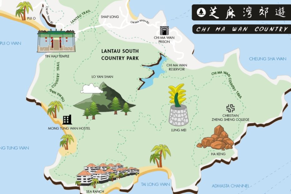
This walk takes you from Pui O, around the Chi Ma Wan Peninsula, to a mysterious and eerie turquoise lake known to only the more adventurous of Hong Kong’s hikers. Allow four hours and take plenty of water; sections of the trail are about as remote as you get in Hong Kong, so a mobile phone is also recommended.
At your starting point in Pui O, adjacent to Tap Tap restaurant, look for the path marked for Ham Tin and Mong Tung Wan. This meanders pleasantly across the buffalo fields before reaching the bijoux hamlet of Ham Tin.
Follow the concrete road to the left and stay on it as it waltzes alongside the river. Watch out for egrets, heron and, if you are lucky, the very rare Brown Fish Owl.
The road bends sharply to the left, followed 100 yards later by a sharp right. You see a small grotto to your right, dating back several hundred years, before emerging to an amazing reveal of the estuary and beach. On your left, a Tin Hau Temple dates back to 1798. Take the coastline path marked for Mong Tung Wan, and enjoy the wonderful views afforded from its vantage point 100 metres or so above the sea.
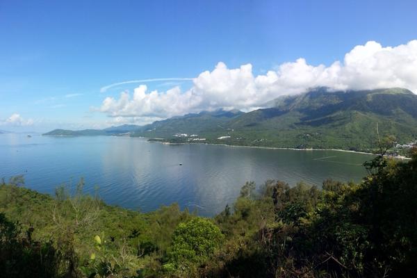
On a clear day you can see Lantau and Sunset peaks, standing like a Praetorian Guard above the South Lantau coastline. The Soko Islands in the foreground give way to Wei Ling Ding Island in the mists beyond.
The path hugs the coast for a mile or so and is an accessway for several gravesites and small columbaria. Many ornamental trees have been planted, including unusual varieties of pine, whose needles scent the air, giving an almost Mediterranean feel to this section of the trail.
Mong Tung Wan is a curio from the 1970s, when it was developed to provide holiday apartments for wealthy Hong Kongers. A small boutique of a beach gives way to three large apartment blocks, now lying empty bar a couple of caretakers, who have the place to themselves. Eerie it most certainly is, a reminder that Lantau has seen surges of development in the past, which have subsequently waned due to economics and demographics.
MONG TUNG WAN TO CHI MA WAN
Follow the path through Mong Tung Wan on its steep ascent up 100 metres of hillside. Once you make it to the top, take a right and continue along the coast.
The path leads you through dense jungle and because it is not widely used, you have a good chance of seeing some of Hong Kong’s most retiring wildlife. There are many spiders – hundreds in fact – their webs brushing your head as if playing some parlour game at Halloween. The spiders take many hours spinning and casting their sticky secretions across the path, which provide them with a natural trap in which to ensnare their prey.
Along this section of trail, gentle and shy barking deer, with their distinctive cry like that of a jackal or dingo, forage nervously on the upper slopes. You might be lucky and glimpse one as you turn a corner, most likely drinking from one of the many streams that tumble to the sea. It will be off as soon as it hears or sees you.
Snakes are prevalent on this trail. They often bask on the open path or on the rocky outcrops that skirt the flanks. Burmese pythons, Chinese cobra and red-necked keelbacks are common local inhabitants.
KINGDOM OF THE TURQUOISE LAKE
The path now turns west along the coast. There is an option to descend to the right to Tai Long Wan (translates as Big Wave Bay, one of five in Hong Kong) and the near-deserted Sea Ranch development. But keep straight on, enjoying views across the sea to Cheung Chau, replete with its harbour, teaming with fishing boats and rows of silver fish drying in the sun.
In the distance, you glimpse Lamma and Central through the thick jungle foliage, which is interspersed with outcrops of natural bamboo and the occasional grove of planted pine. This part of the island is strewn with large boulders placed thousands of years ago by Goliathan forces of nature. The path continues for another 3 kilometres before arriving at a four-way junction marked with a yellow concrete lotus leaf. Take the path marked Chi Ma Wan Country Park Management Centre.
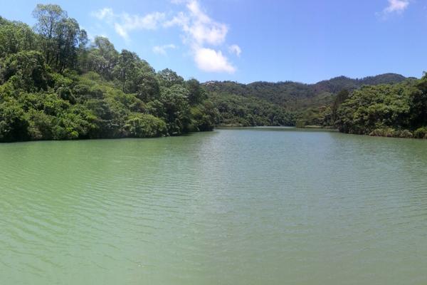
Now the path starts to descend into a lush and mysterious valley; streams flow on either side and rows of Camphor trees beckon you on. Wending your way downwards, you find yourself in a swampy, misty, humid place: the Kingdom of the Turquoise Lake. Soon you spot its brilliant-blue shores on your left, the sun glistening atop its deep and mesmeric interior. Continue and its expanse opens up – a small yet gracefully formed reservoir, built to service the two prisons that sit nearby.
The path emerges after another five minutes at the reservoir wall and from here you can cross to the aforementioned management centre, which sits in the deep and sheltered shadow of the watery expanse above.
THE HOMEWARD STRETCH
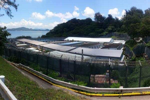
A jungle track, part-concrete, leads you to the entrance of Chi Ma Wan Prison, now devoid of inmates. Dating from 1956 the original prison was the first ‘open’ facility in Hong Kong, later upgraded to house more serious offenders, with high double fences added to the original exterior. Take the road past the now defunct prison officers’ club, where the karaoke stage and backgammon tables lie dormant, waiting for the next twist in their history.
The road takes you along the outer fence, continuing along the coast. An old incinerator on your left, now overgrown with creeper vine, once burned the rubbish of small local villages, many of which are long-since abandoned. The second of Chi Ma Wan’s prisons emerges in front of you, this one a former Vietnamese refugee camp, later converted to a youth offenders’ institution. The path rises above it, affording views of the cell blocks and workshops now gathering moss and dust.
Follow the road to Shap Long, a charming series of three hamlets, astride an estuarial inlet and flood plain, home to water buffalo and migratory birds. You may also see a colony of fiddler crabs, large claws to the fore, during food gathering stints at low tide. Such is their number that if you stand still and allow them to emerge from the protection of carefully formed mud burrows, they create a blanket of moving oranges and reds – a true kaleidoscope of nature.
From Shap Long you can take the well-marked coastal path back to Mui Wo, another two hours of hiking, or head back up the hill to Ham Tin and your original route from Pui O.