COMPLETING THE LAST THREE SECTIONS OF THE 70-KILOMETRE LANTAU TRAIL , CLAIRE SEVERN ENDS UP WHERE SHE STARTED – IN MUI WO.
PHOTOS BY Duey Tam & Andrew Spires
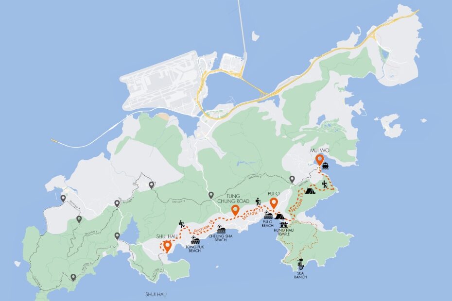
Day four of our Lantau hike – the final stretch. Fifty kilometres down, just 20 left to go. The sun is shining, the cows are out in force, and we are all set to tackle sections 10 to 12 of the Lantau Trail.
Starting out at the end of section 9 – in the laid-back village of Shui Hau – our first challenge is to figure out which way to go. The local bovines aren’t helping us out much, casually munching their breakfast directly in front of the sign for the trail, but we follow our noses and soon find the path leading uphill, to the left as you head out of the village in the direction of Tong Fuk.
A moderate climb, the path consists of steps most of the way, which raises the heart rate slightly, but we soon reach the catchwater, where the hike becomes a lot easier. The flat ground here means that we can pick up the pace a little to cover some distance.
Along the way, breaks in the trees offer glimpses of the South China Sea, and we take the opportunity to pause for a while to enjoy the panoramic view across the stunning Cheung Sha coastline.
SECTION 11: TO PUI O
Continuing on, we soon reach the end of section 10, where the catchwater crosses the old Tung Chung Road. There is a large picnic area at this point, which provides a handy place to stop and refuel if you can pick your way through the sleeping cows.
Carrying on to section 11, the trail follows the catchwater for another 3 kilometres before bearing right onto a hillside path at distance marker L119. It is actually quite a relief to reach the end of the catchwater – the constant slight camber is tough on the legs.
At this point, the path is pretty much all downhill, the route overlooks the village of Lo Uk and passes an enchanting little waterfall before affording a glimpse of Pui O, which marks the end of the trail’s penultimate section.
Arriving in Pui O village, we turn right down the side of Bui O Public School towards the beach then head left along the road, past Pui O campsite and on towards Ham Tin to begin section 12.
SECTION 12: HAM TIN
The sheer amount of wildlife around Ham Tin is wonderful to witness. Fish, birds, butterflies – it’s easy to see why the Agriculture, Fisheries and Conservation Department considers the large water inlet from the sea here to be ecologically important.
One of the most impressive sights is still to come, however. In fact, it is just around the corner, where the trail meets Ham Tin Wan and offers a sweeping view back over Pui O’s famous dark sands. There is also a small Tin Hau temple at this point, believed to have been built in the Ming Dynasty.
On a clear day you see multiple islands, many uninhabited except for the odd turtle. The stomping ground of pirates in days gone by, this stretch of sea is still a centre of skulduggery. In 2012, one of Hong Kong’s largest drug smuggling seizures occurred just 700 metres from this very spot.
Heading out of Ham Tin, the trail heads inland up a steep slope, cutting out the Chi Ma Wan Peninsula. If time permits, turn right here instead to check out the infamous Sea Ranch further along the coast. What was designed as a HK$40 million utopian pocket of seclusion, with 200 five-star apartments, now sits as a virtually inaccessible, seemingly deserted anomaly.
Cresting the Tai Long Plateau, the view is remarkable and Sea Ranch’s gleaming towers only add to that. The real sense of isolation and privacy is what must have persuaded the party people to buy here back in the late ‘70s.
THE LAST STRETCH: TO MUI WO
Nostalgia trip over, we make our way back to the trail. Spotting the signs for Mui Wo via Pak Fu Tin campsite, we turn left and start climbing a stepped path. This is where the hike gets a bit harder, but the path levels out soon enough and the trees overhead provide some welcome shade.
This respite is brief, however, because the path soon starts to rise again. But my, is the effort worth it! We emerge from shrouded woodland to an open vista, which has to be one of the finest in Hong Kong. The view from the top is incredible, encompassing both Sunset and Lantau peaks along with a seemingly endless stretch of coastline, from Pui O, across Cheung Sha and all the way back to where we started the day – Shui Hau.
After breathing it all in, we begin our descent towards our end point of Mui Wo, keeping right at the fork in the road. My favourite thing about this section of the hike is the quiet. Apart from the occasional tweet of birdsong, everything is still and peaceful, which makes for a very relaxing stroll through the woods.
A short while later, we reach distance post L133, where we follow the concrete road down to the right. The signs then point to a set of steps on our left. Just 3.5 kilometres further and we will be in Mui Wo.
The path from here is open to the elements, but the upside of that is more great views of the coast. Before long, Hei Ling Chau Typhoon Shelter comes into view. We’ve nearly made it.
As we head into Mui Wo, it’s somewhat sad to think our adventure is over. That crazy idea we’d had all those months ago about walking the entire length of the Lantau Trail has become reality. We’ve done it! And we’ve gathered some great memories along the way.
Sure, it had been challenging at times – Lantau Peak and the spider-infested ‘Tunnel of Doom’ leading to Tai O spring to mind – but what an experience! Lantau is, quite simply, magnificent. If you get the chance to hike the Lantau Trail from start to end, do it. You won’t regret it. We certainly don’t, even if we did lose the odd toenail along the way.